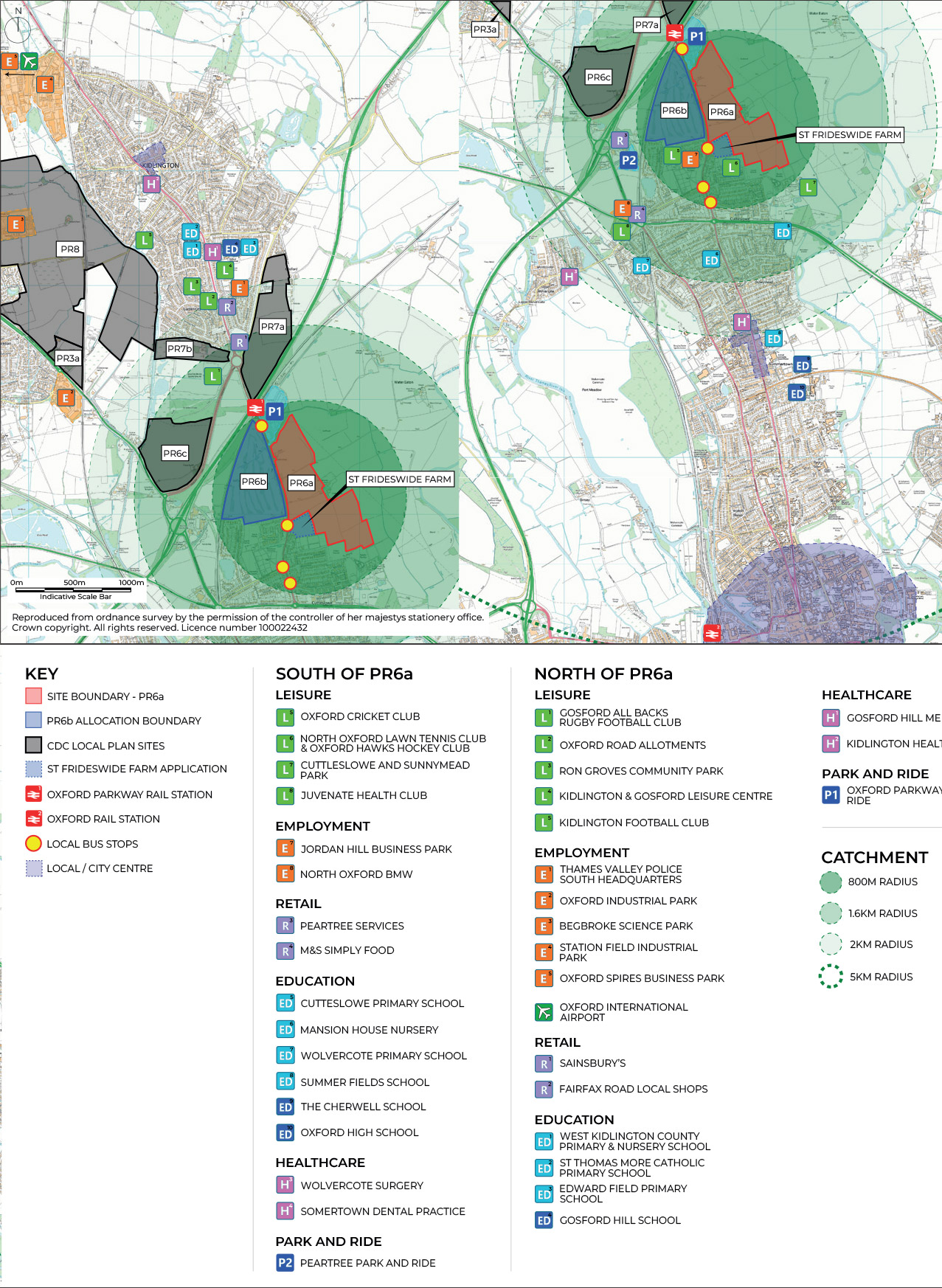
Transport and Access Strategy
Oxfordshire County Council’s recently adopted Local Transport and Connectivity Plan (LTCP) outlines a clear vision to deliver a net-zero Oxfordshire transport and travel system. The LTCP has a number of headline targets including:
- By 2030 to replace or remove 1 out of every 4 current car trips in Oxfordshire and increase the number of cycle trips in Oxfordshire from 600,000 to 1 million cycle trips per week; and
- By 2040 to deliver a net-zero transport network and replace or remove an additional 1 out of 3 car trips in Oxfordshire
Transport and Access Strategy
Against this background, key aspects of the transport strategy include:
- A walking and cycling super highway along the A4165 Oxford Road frontage which forms part of Oxfordshire County Council’s wider plan to improve cycling connections between Kidlington and Oxford City. Oxfordshire County Council’s proposals are to accommodate where feasible one directional segregated cycle lanes and footways either side of the Oxford Road / Banbury Road
- Convenient and attractive pedestrian and cycle links into the surrounding highway network and local area
- Accommodating buses that will remain on Oxford Road / Banbury Road but with new bus stops that are within a reasonable walk distance of the new homes (both PR6a and PR6b; and
- Vehicular accesses to the site from Oxford Road that prioritise safe crossing movements for pedestrians and cyclists.
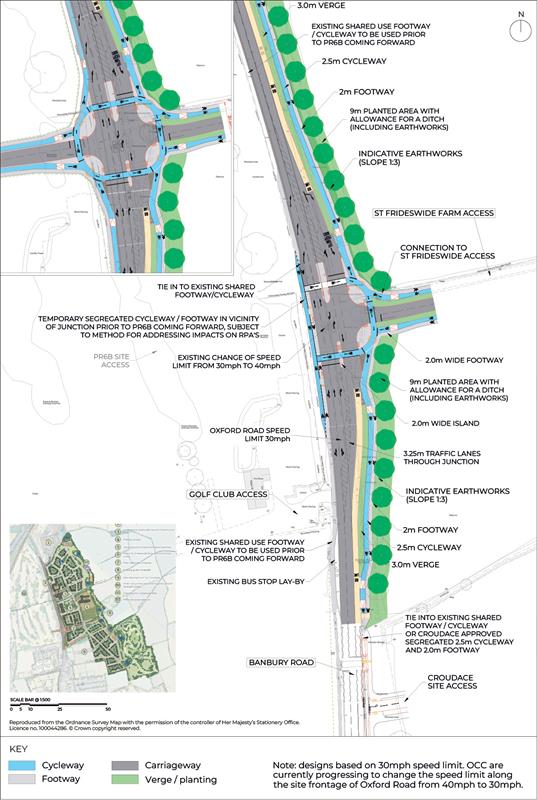
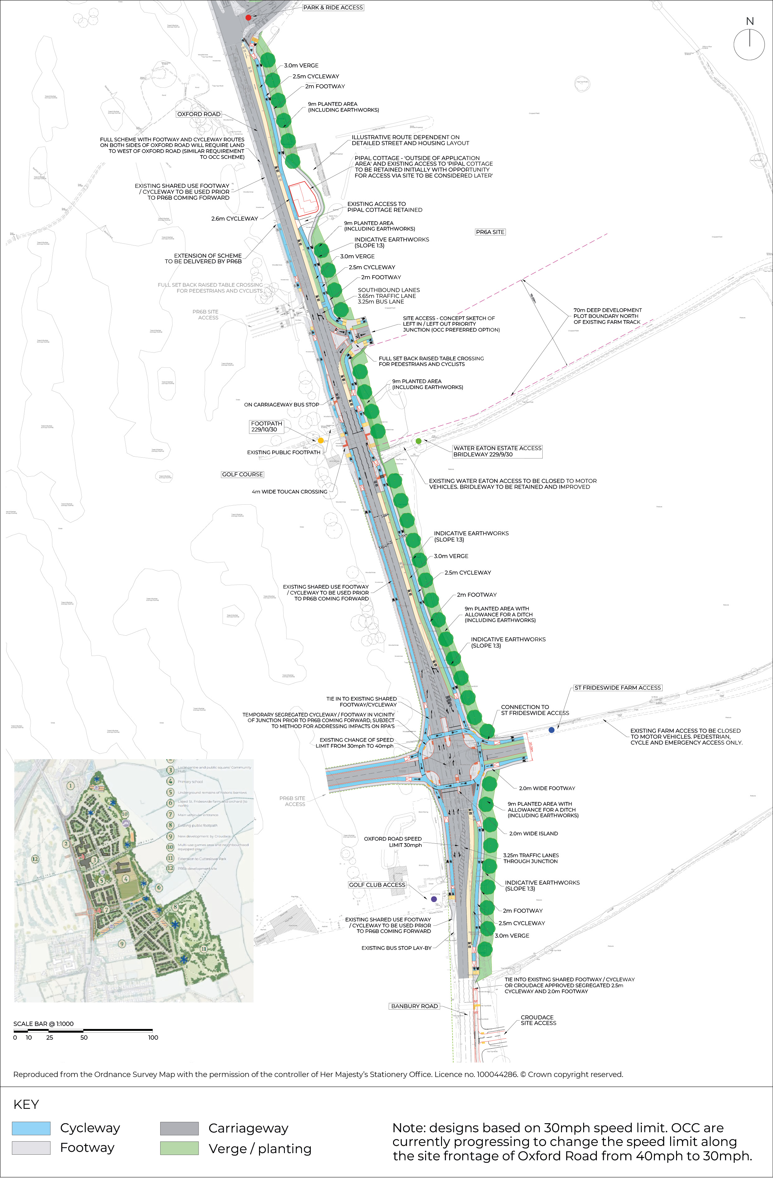
The access strategy includes:
- A CYCLOPS (Cycle Optimised Protected Signal) Junction designed with an orbital cycle route around the junction situated to the south of the existing St Frideswide farm access. The design, which links into the cycle super highway, leads to the segregation of walking and cycling from vehicles, creating a safe environment for cyclists and pedestrians. The design is capable of accommodating a fourth / western arm for a future access into the PR6b site
- A simple ‘Left in Left out’ priority T-junction situated north of the existing Water Eaton Estate access road
- The existing St Frideswide Farm and Water Eaton accesses from Oxford Road to be closed to vehicular traffic and to be turned into pedestrian / cycle accesses (bridleway access for the Water Eaton access)
- A toucan crossing (pedestrian / cycle controlled crossing) of Oxford Road situated between the Water Eaton bridleway and the public right of way going through the PR6b site
- Bus stops on Oxford Road near the proposed toucan crossing and retention of the southbound bus lane
- A pedestrian / cycle access into the recently approved Croudace development to the south of the site
- The Pipal Cottage access from London Road being closed to traffic and Pipal Cottage being accessed from within the site; and
- A potential ‘school street’ along the site’s central spine, along the primary school frontage. This will be a ‘no though route’ during school drop off and pick up periods, limiting vehicular access to the school and improving the environment for school children in the immediate vicinity of the school.
Click image to enlarge Pinch image to enlarge
Our proposals sections
- Introduction
- Our proposals
- The development
- The scheme parameters
- Masterplan
- Character and placemaking
- Responsible ownership & stewardship
- A sustainable development
- Transport
- Sustainable transport improvements
- Green infrastructure
- Site heritage
- Ground conditions and utilities
- Ecology and biodiversity
- Landscape and visual
CYCLOPS junction
Image of potential CYCLOPS junction
Click image to enlarge Pinch image to enlarge
Signal controlled junction
Image of potential typical signal controlled junction
Click image to enlarge Pinch image to enlarge
Left in Left Out junction
Image of potential Left in Left Out junction
Click image to enlarge Pinch image to enlarge